


De l’autre côté se trouvent la lagune de Thau avec ses parcs à huîtres et le massif de la Gardiole et en toile de fond le Canigou, les Pyrénées Orientales au plus beau jour. Une impressionnant vue sur le cordon littoral sableux, qui sépare la mer bleue de la lagune de Thau, vous attend.
Le belvédère offre un point de vue stratégique pour découvrir Sète si particulière. Construite autour de ses ports, parcourus par des canaux qui offrent le passage entre la mer et la lagune de Thau, la ville est reliée par les neuf ponts qui sont à découvrir. Sète mérite bien son surnom d’île singulière ou de petite Venise languedocienne.
Explorez les petits chemins de Mont Saint-Clair à pied et flânez autour des villas traditionnelles du début du 19ème siècle, tout en profitant d’une vue imprenable à chaque tournant !
La montée : itinéraire à pied
Combien de temps pour monter au mont saint-clair ? Avec ses 225 marches (facile à monter et large) vous attendent afin de profiter d’un paysage à 360 degrés avec vue sur la Méditerranée, le port, la lagune de Thau et le cordon littoral avec ses vignes et plages dans environ 20-25 minutes. Un conseil, en été, évitez la pleine chaleur et marchez de préférence de bon matin ou en fin d’après midi. Au lever ou au coucher du soleil, le point de vue est toujours splendide.

La lagune de Thau et le quartier Le Barrau
Du Pouffre, notre maison de vacances à Sète, prenez à droit sur la Grande Rue Haute. Allez tout droit, tournez à gauche sur la rue Garenne puis tout suite à gauche sur la Rue de Villefranche. Continuez sur Rue Louis Ramond qui devient Rue Belfort. Tournez à gauche sur Impasse des Lauriers puis tournez à gauche sur Chemin de Biscan Pas pour emprunter les marches et rejoindre le sommet. Temps de la montée : 19 mn, 1.1 km.
Du Piade, notre appartement de vacances à Sète, empruntez la Rue de La Revolution, tournez à droite sur Rue du Maire Aussenac, puis tournez à gauche sur Rue de la Caraussanne, tournez à droit sur Rue Louis Ramond qui devient Rue Belfort. Tournez à gauche sur Impasse des Lauriers puis tournez à gauche sur Chemin de Biscan Pas pour emprunter une belle volée de marches et rejoindre le sommet. Temps de la montée : 27 mn, 1.7 km.
Arrivé au sommet, la récompense est au bout de l’effort. Au pied de la Croix Saint-Clair, le belvédère offre une vue plongeante et saisissante sur Sète, le port, la mer ainsi que sur la côte Languedocienne. Elle était inaugurée en le 19 février 1983 et remplace celle détruite par la violente tempête de 1982.

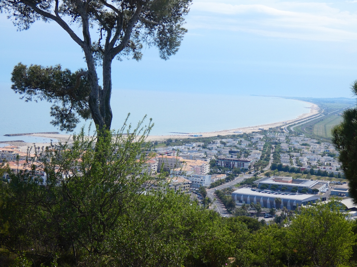
Vue à partir du Mont St Clair sur la ville de Sète et la côte Languedocienne
La croix de Saint-Clair
Le Mont Saint Clair porte à son sommet une croix. Elle embrasse la ville, elle est à Sète ce que le Christ rédempteur du Corcovado est à Rio ou ce qu’est la statue de la Liberté à New York. Elle est allumée à la nuit tombée, et ce toute l’année..

Le Croix de Sète sur le Mont Saint Clair
La croix lumineuse perpétue le feu que le Sétois ont allumé le 12 juillet 1932 pour célébrer le saint qui a donné son nom au mont. Une plaque de marbre se trouve à son dos, nichée dans le socle, sur laquelle sont gravé ces mots : « Du haut de la Croix Jésus regardait la ville. Debout à ses pieds Marie pleurait. Que la Croix garde ceux qui l’ont élevée ». Proche de cette croix, a été inaugurée en 1990 une Stèle offerte par les enseignants d’Algérie tués pendant la guerre de l’indépendance.
La chapelle Notre-Dame-de-la-Salette
Au sommet se trouve la chapelle Notre-Dame-de-la-Salette où les messes sont régulièrement célébrées. Cette chapelle est consacrée à la Vierge qui apparût le 19 septembre 1846 à deux enfants du village de La Salette-Fallavaux dans l’Isère. En 1864, Henri Gaffino, curé doyen de Sète et de ses ports, dédie la chapelle située au sommet du Mont Saint Clair (évangélisateur de la région) à Notre Dame de la Salette.

Chapel de Notre Dame de la Salette de Sète
En 1861, la chapelle fut reconstruite, s’appuyant sur les restes de pans de murs militaires ce qui explique quelque peu son comportement sévère. De l’extérieur, la chapelle ressemble plus à un fortin qu’à un lieu de culte car avant la création de la ville de Sète, le duc Henri 1er de Montmorency, gouverneur du Languedoc, fit construire un fortin à l’emplacement d’un antique poste de gué romain après avoir chassé les pirates de l’île.
La statue de la Vierge a été érigée en 1866 pour commémorer le bicentenaire de la ville. Son clocher servait également de repère géodésique.
Cette chapelle est un lieu traditionnel de pèlerinage. Tout les 19 du mois une messe y est célébrée.
En poussant la porte, vous serez sûrement émerveillés, par les fresques réalisées par le peintre Bringuier (de 1951 à 1953) qui couvrent l’intégralité de l’édifice. La partie de la chapelle dédiée à Sainte Rita et Notre Dame de la Chapelle est également couverte d’ex-votos (des offrandes faite à dieu en demande d’une grâce ou en remerciement). Une fin de visite de la chapelle Notre-Dame-de-la-Salette qui vous ne vous laissera pas indifférent !
La forêt domaniale des Pierres Blanches
De la forêt domaniale des Pierres Blanches, on peut apercevoir la lagune de Thau et ses parcs à huîtres. Empruntez le Chemin des Pierres Blanches sur la droite et à 1.5km (15 mn à pied), à l’autre bout de la colline, la forêt domaniale des Pierres Blanches, propriété de l’État, est idéale pour les marcheurs.
La forêt domaniale des Pierres Blanches avec ses 27 ha de pinède offre de nombreux sentiers pédestres avec des vues extraordinaires sur la Méditerranée. Depuis le belvédère et la table d’orientation, la vue panoramique sur le lido qui court entre la mer et la lagune est à couper le souffle.
Vue panoramique de la forêt des Pierres Blanches sur les plages de Sète jusqu’à Marseillan
De nombreux sentiers pédestres balisés aux senteurs de pins et de thym ont été tracés. Des panneaux pédagogiques permettent de découvrir près de 400 espèces de plantes cohabitent dont une quarantaine peu répandue. Des coins aménagés permettent aussi au visiteur une pause bienvenue.
Marchez, picniquez ou reposez-vous au forêt des Pierres Blanches
Avant de devenir la forêt domaniale de Sète, ces terrains ont servis de zone de jardinage et de pâturage pour les familles d’éleveurs (moutons, caprins, vaches) qui occupaient les maisons de pierre nommées « baraquettes ». Pendant la seconde guerre mondiale, les arbres du Mont Saint-Clair, notamment les chênes verts, ont été utilisés par les sétois pour leur chauffage. L’occupant allemand a investi ces lieux pour la surveillance d’un débarquement éventuel.
En 1972, face à la menace d’urbanisation, elle est devenue « forêt domaniale » gérée par l’Office National des Forêts pour garantir durablement sa vocation d’espace naturel. Aujourd’hui, l’ONF et la commune de Sète investissent sur le site pour – offrir au public un espace accueillant ; – maintenir la diversité des paysages et des milieux naturels ; – garantir la pérennité de la forêt.

Les sentiers au forêt des Pierres Blanches
La descente
Avant de descendre, vous pouvez vous restaurer au boire un verre au restaurant grillade Le Safari. Pour descendre, vous pouvez revenir sur vos pas ou bien prendre le bus ligne 5 pour descendre au Pouffre ou le centre-ville.
Les plus téméraire peuvent profiter du retour pour aller se baigner à la plage de la Corniche (20 mn à pied ; 1.6 km) et puis prendre le bus du retour la ligne 7 à l’arrêt Ifremer et descendre l’arrêt Commissariat pour notre appartement de vacances Le Piade. Sinon la ligne 5 à l’arrêt Notre-Dame Souveraine du Monde et descendre à l’arrêt Cimetière Marin pour revenir à notre maison de vacances Le Pouffre.
Montez le Mont Saint Clair en bus
Si vous ne voulez pas montez le Mont Saint Clair à pied, prenez la ligne no. 5 à l’arrêt Cimetière Marin à partir de notre maison Le Pouffre ou de la Promenade J. Baptiste Marty au centre-ville.
Bonne visite !